 RSS Feed


 September 6th, 2020
  Awake Goy
 Archaeologists have flown high-tech drones over the rainbow in Kansas, revealing a large circular earthwork. The recently discovered Kansas earthwork is thought to be linked to a famous indigenous site.
For many, Kansas is a name that brings to mind images of a little girl in red shoes being sucked into the air in a cyclone and being catapulted over that rainbow into the Land of Oz. And while Wizard of Oz became one of the bestselling books of the 20th century, archaeologists have now sent high-tech drones into the Kansas skies; and they too discovered something almost otherworldly, and deeply-magic, but of a much more ancient nature than Oz.
Heat Mapping to Find the Kansas Earthwork
A new study by lead author Professor Jesse J. Casana, chair of the department of anthropology at Dartmouth College published in American Antiquity , says the team of archaeologists conducted their survey at a ranch located in the lower Walnut River valley. The author describes the local topography as flat, with no visible archaeological features. However, flying state of the art scanning equipment over this landscape located in present-day Arkansas City, Kansas, near the Arkansas River, revealed “an ancient, circular shaped ditch measuring 50 meters wide and approximately 2 meters thick”.
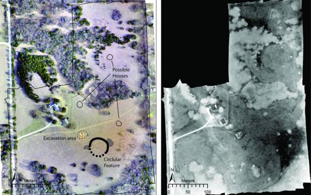
Left: Drone-acquired orthoimage of the site showing major features discussed in the paper. Right: Thermal images mosaic collected from 11:15 pm-12:15 am. ( Jesse Casana, Elise Jakoby Laugier, and Austin Chad Hill )
The scientists explain in their paper that as the soil eroded it filled up the circular ditch with different types of soils than the original mud, and this means the structure retained water differently, which the researchers say gives the site “unique thermal properties.” Furthermore, the water retention levels at the site also impacted vegetation because grass growth was more vigorous than other vegetation, and using “near-infrared imagery,” the team of scientists were able to identify areas that had been filled in at the Kansas earthwork.
Droning the Past at Night Time
Speaking with Eureka Alert about this new discovery, Professor Casana said the results provide evidence for what may have been “a single, sprawling population center” and that his team’s findings demonstrate that undiscovered monumental earthworks still exist in the Great Plains of the U.S.A, but that a “ different archeological approach ” is required to recognize them.
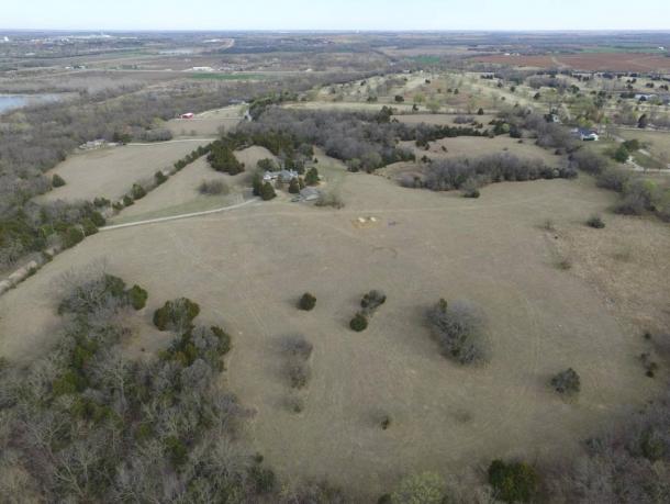
Aerial view of the recently discovered Kansas earthwork site. ( Jesse Casana )
The new method the professor referred to means working at night because archaeological features have fluctuating thermal effects and after the ground cools down at nighttime hidden features below ground level emit thermal infrared radiation, at different rates, which the researchers captured using drones. And with their high-resolution aerial data the team reproduced detailed thermal and multispectral imagery of the lost 18-hectare archaeological site.
What Exactly Has Been Discovered?
Now that we have answered “how” the archaeologists made this discovery, it’s now time to look at “what” exactly they discovered. It was in April 2017 that the New York Post reported that the location of “ Etzanoa” was finally discovered when a local teenager unearthed a cannonball that was fired in a battle near Arkansas City, Kansas, in the year 1601 AD. Local researchers presented this artifact as evidence pinpointing Etzanoa , a historical Wichita site that flourished between 1450 and 1700 AD.
In 1904 George Parker Winship wrote The Journey of Coronado, 1540–1542, from the City of Mexico to the Grand Canon of the Colorado and the Buffalo Plains of Texas, Kansas, and Nebraska , in which he told the story of Spanish conquistador Francisco Vásquez de Coronado visiting central Kansas in 1541 AD and naming Wichita settlements, “Quivira.” Then, in 1594 AD, the Umana and Leyba expedition visited the Etzanoa site before Spanish conquistador Juan de Oñate visited in 1601 AD and recorded “the Great Settlement” (Etzanoa) as housing “20,000 Wichita people ” who he called “Rayados” – a Spanish word meaning “striped” because Wichita people painted and tattooed straight lines onto their faces and bodies.
Professor Casana describes the circular feature as a “council circle,” which were centers of tribal communities in North America, believed to have associations with astronomy, but they also served as ceremonial, political, and defensive structures.
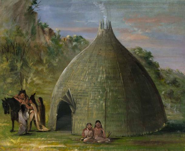
Wichita Lodge, Thatched with Prairie Grass (1834-1835) by George Catlin. ( Public Domain )
In conclusion, using high-tech multi-sensor drones the large circular Kansas earthwork is suspected to be the remains of the legendary council circle at Etzanoa, which raises one major question: how many others are out there waiting to be discovered by thermal sensing drones.
Top Image: Aerial view of the Kansas earthwork site and drone-acquired orthoimage showing major features of the site. ( Jesse Casana, Elise Jakoby Laugier, and Austin Chad Hill )
By Ashley Cowie
 Posted in
  Tags:
Tags: 


