 RSS Feed


 July 23rd, 2017
  Awake Goy
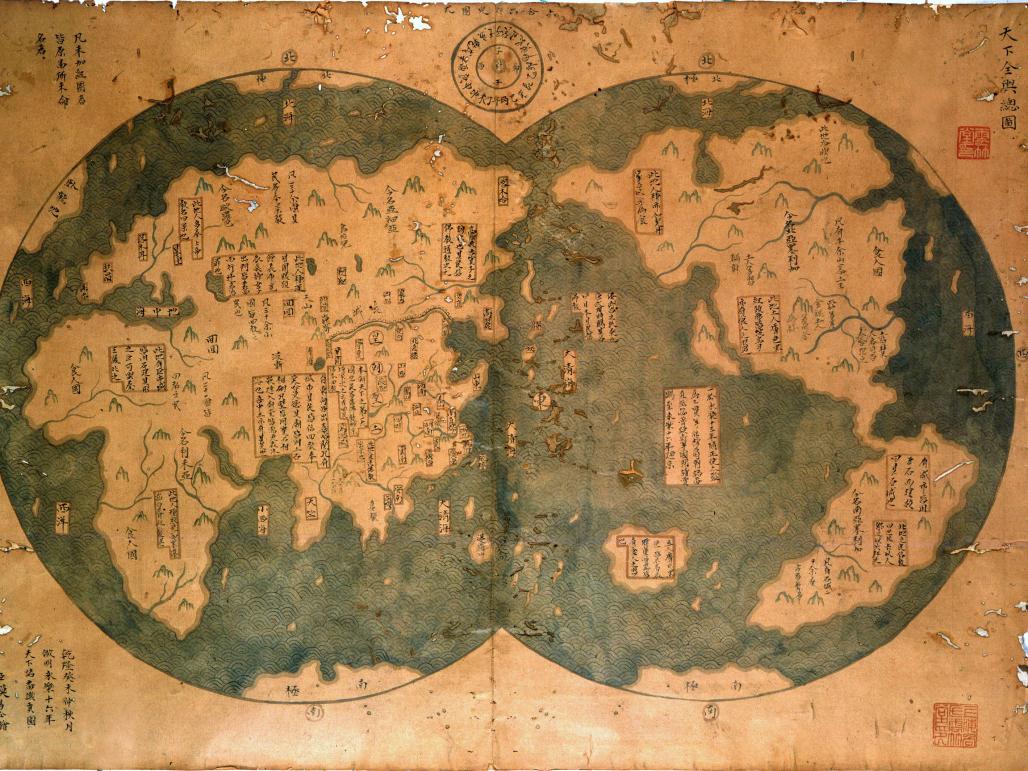
In 1405 a Chinese Muslim eunuch, Zheng He, launched the first of seven voyages west from China across the Indian Ocean. Over the next 30 years, in command of the world’s largest fleet and funded by the Ming emperor, he sailed to the east coast of Africa and deep into the Persian Gulf. That much, we know, is true.
But some people believe he went much farther—and this map is one reason. Entitled “General chart of the integrated world”, it is apparently an 18th-century copy of a 1418 map which claims to show the world that Zheng He discovered. If it is real, it rewrites history, for it shows that he circumnavigated the globe and—most provocatively—that he discovered America more than 70 years before Columbus.
The map came to light in 2001 when a Shanghai lawyer, Liu Gang, says he bought it from a local dealer for around $500. He believes it proves that Zheng navigated the waters around both poles, the Americas, the Mediterranean and Australia too. In 2003 Gavin Menzies used it as evidence for his book “1421: the year China discovered the world”.
The outlines of the continents on the map are instantly recognisable. Some aspects are characteristically Chinese: the blue, fan-like waves are part of China’s cartographic tradition, as are the annotations with textual descriptions of places. The map is impressively detailed. It shows the two hemispheres of the world, a convention for depicting the round Earth on flat paper. The contours of North and South America are clear, as are the rivers running from far inland. We can see the Arctic. And the Himalayas, among whose foothills Zheng He was born, are marked as the highest mountain range in the world.
It is these detailed elements, however, that give the game away. Only Europeans represented the globe this way. European explorers completed travels like this over the course of hundreds of years, rather than Zheng He’s 30, which makes it almost impossible that his maritime voyage would have had such a specific grasp of river courses. The Arctic appears first on a Ming Chinese map only in 1593. And the world’s greatest mountain range was labelled as such only in the 19th century.
Source:
Eddie is the founder and owner of www.WorldTruth.TV. This website is dedicated to educating and informing people with articles on powerful and concealed information from around the globe. I have spent the last 38 years researching Bible, History, Alternative Health, Secret Societies, Symbolism and many other topics that are not reported by mainstream media.


Source Article from https://worldtruth.tv/did-china-discover-america-this-map-claims-that-a-chinese-muslim-beat-columbus-to-it-but-is-it-real/
 Posted in
  Tags:
Tags: 


