 RSS Feed


 June 3rd, 2018
  Awake Goy
“Joppa from the sea,” photograph by P. Bergheim, between 1860 and 1880. Library of Congress, LC-USZ62-106225.[1]
What fault have we Palestinian Arabs committed … Release us from the Zionists greed which is increasing from day to day … Were we liberated by the Allies from the Turkish yoke to be put under the Zionist yoke? (—telegram from the Jaffa Moslem-Christian Committee to the British government, March, 1919) [2]
A century after that plea from Jaffa, this article is a plea not to forget Jaffa on the 1947 partition map of the sequence illustrating the Palestinian loss of land from 1946 to the present. It is a cartographically cleansed dot’s right-of-return.

In this detail from a 1475 map of Palestine, note Jaffa, just to the left of the center binding, by the ship. East is at the top, so Gaza is in the lower right (south). Woodcut, from the Rudimentum Novitiorum, published in Lübeck by Lucas Brandis, 1475.
The ancient port city of Jaffa was long a hub of Palestinian life — culturally, commercially, politically, artistically — until European invaders brutalized the city and drove its people into the sea in early 1948. Much of this gem on the Mediterranean was destroyed, and more than ninety-five percent of its population expelled by the Zionist militias in their pursuit of ethnic purity in their settler state. [3]

In this sequence, the “UN PLAN 1947” map is correct (dot enlarged slightly here for visibility). Click image for source, Palestine Awareness Coalition.
But like much of the area conquered by the Zionists that year, Jaffa was not even in their settler state. The Jewish Agency (/Israeli government) had agreed that Jaffa would be part of the Palestinian state — or, rather, it agreed when within earshot of the United Nations, until after UNGA Resolution 181, the UN Partition plan that effectively created the Israeli state, was shoved through the UN by the United States.
Partition’s architects acknowledged that keeping Jaffa non-contiguous with the rest of Palestine created problems for the Palestinians; but alternatives that kept Jaffa contiguous created a parallel problem for the Zionists. Resolution 181 made Jaffa a Palestinian island, accessible to the rest of Palestine either by sea or through Israel.
Anti-Palestinian settler violence had begun to escalate during the summer of 1947, and in December, once the ink on Resolution 181 was dry, the Jewish Agency already began breaking its territorial agreements, as anti-Palestinian violence escalated markedly. The Irgun launched a seaborne attack on Jaffa on December 29, with a final onslaught by the Irgun and Hagana in April (the Irgun then formally incorporated into the Hagana, ‘official’ Jewish Agency military).
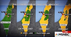
When in 2015, a major US television station, MSNBC, aired this land loss map, it caused such outrage among the Narrative-keepers that the station apologized. The apology should, rather, have been to the Palestinians for its omission of Jaffa as part of Resolution 181’s allocation to the promised Palestinian state. Click image for Mondoweiss article.
“It should be made clear,” High Commissioner Cunningham reported, that the attacks were “indiscriminate and designed to create panic amongst civilian inhabitants. It was not a Military operation.” When Cunningham found the media reporting the ethnic cleansing as “Jewish military successes,” he sent a telegram to British and US officials in protest: these “successes” are, in truth, “operations based on the mortaring of terrified women and children.”
A half century later, a book published by the Israeli Ministry of Defence justified the ethnic cleansing of Jaffa by calling it “a festering cancer in the middle of the Jewish population.” [4]
By the time the fateful day of May 15, 1948 arrived — the end of the British Mandate and the unilateral declaration of the Israeli state — most of the original 120,000 inhabitants of Jaffa and its environs were already refugees, destitute, many trapped in Gaza forty miles to the south. Of the roughly 4,000 that were still in Jaffa, the Israeli militias rounded up these ethnically-wrong hold-outs and sealed them off, using the al-Ajami neighborhood as a virtual military prison.
In December that year, UNGA Resolution 194 reaffirmed what should never have needed anyone’s reaffirmation: the refugees’ right to return home. For many of those now facing starvation in camps in Gaza, ‘home’ meant Jaffa; yet throughout the years that followed, they were shot dead on sight if they tried.
Thus Israel’s deadly siege of Gaza was in full force by the end of 1948. The election of Hamas in 2006, to which Israel now falsely attributes its siege, was instead the result of fifty-eight years of Israeli intransigence.
With the theft of this jewel of Palestinian civilization, tens of thousands of settlers from abroad quickly poured in and commandeered Jaffa, its homes, its orchards, it businesses, its libraries, its presses. In October of that year the Israeli cabinet formally decreed Jaffa’s union with Tel Aviv. Both the United States and the United Nations were suddenly impotent. [5]
That impotence was described in a telegram from Sir Hugh Dow, British Consul-General in Jerusalem, to the Foreign Office (September 1, 1948):
If, instead of the Jews seizing Jaffa, the Arabs had succeeded in establishing themselves in Tel Aviv, would the United Nations have agreed to the retention of Tel Aviv in an Arab State? [6]

In 2012, the creators of these brilliant billboards got them up in Boston transit. In no way to detract from that Herculean feat, note that the green dot for Jaffa is missing on the Partition map. Click image for Mondoweiss article.
Fast-forward to today. That Jaffa was on the Palestinian side of partition is usually forgotten in the familiar series of maps used to illustrate ‘disappearing’ Palestine. Jaffa is shown as Israeli, a serious error in Israel’s favor. The omission of Jaffa also minimizes the absurdity of the Partition scheme itself.
The maps are otherwise correct, showing an interior region and a coastal region corresponding to today’s West Bank and Gaza, roughly twice the size of what remained by the end of 1948. (The so-called ‘1967 borders’ delineate a Palestine about half that specified by the UN in 1947, and those 1947 borders were already disproportionately generous to the Zionists, an attempt to delay Israel’s expansionist desires).
The Israeli Creation Myth is losing its efficacy these days, thanks largely to the increase in understanding of the period preceding 1948. It is in that spirit that I ask that we check the 1947 UN Partition map in our land-loss map sequences — and if there’s no conspicuous dot for Jaffa in the color of the Palestinian side of Partition (usually green), let’s add it.
That dot is a stolen gem that must be returned to its owners — and its owners returned to it.
Tom Suárez is the author of three major books on the history of cartography.

“Joppa. Approach from the east” [between 1870 and 1880], by the important French photographer Félix Adrien Bonfils (1831-1885), “one of the first commercial photographers to produce images of the Middle East on a large scale” (Wikipedia). Library of Congress, LC-USZ62-106226
- Note that the author has conservatively modified the Library of Congress scan as follows: changed from grayscale to color; discreetly restored some contrast along the top of the buildings to undo loss; remove the extra margin with the catalog number. The LoC listing dates the photograph between 1860 and 1890, but other listings for Bergheim, from the LoC and auction listings, state 1860-1880, suggesting that 1890 is unlikely.
- The National Archives (Kew), FO 608/99.
- Grim footage of Jaffa after its conquest by Israel has been rescued from obscurity by Rona Sela and can be seen in her new film, “Looted and Hidden” (2017). At writing, the filmmaker, a curator and researcher of visual history and culture, has made her film available online. Captions in English https://vimeo.com/213851191; Captions in Arabic and Hebrew https://vimeo.com/257286457
- See Suárez, State of Terror, 259-260. The “festering cancer” quote is from Joseph Kister, The Irgun the Story of the Irgun Zvai Leumi in Eretz-Israel [Ministry of Defence Publishing House, 2000]
- Sami Abu Shehadeh and Fadi Shbaytah, “Jaffa: from eminence to ethnic cleansing,” The Electronic Intifada, February 26, 2009
- The National Archives (Kew), FO 800/487, numbered ‘240’ in file.
Source Article from http://mondoweiss.net/2018/06/disappearing-palestine-spotlight/
 Posted in
  Tags:
Tags: 


