 RSS Feed


 February 5th, 2021
  Awake Goy
 The German Archaeological Institute has just released detailed updated digital maps of the ancient city of Pergamon (also known as Pergamum). For the first time since 1973, the new cartography includes all known archaeological locations in Pergamon.
Pergamon: One Of The Best-preserved Ancient World Cities
One of the best-preserved cities of the ancient world, Pergamon sits near modern-day Turkey’s west coast next to the city known as Bergama. Pergamon was a prosperous, cosmopolitan city that flourished in antiquity starting with King Lysimachus who ruled from 301 – 281 BC. It became the capital of the kingdom of Pergamon after the fall of the Lysimachian Empire. Then, the Attalid dynasty ruled Pergamon from 281 – 133 BC. It remained a Hellenistic territory until 133, when the city was bequeathed to Rome because Attalus III died without an heir.
The city continued to grow and develop well into the Byzantine era, but the digitalized map recently released focuses on the 3rd century BC, which was the Hellenistic period . When archaeologists research Pergamon, they only look at its acropolis, but Pergamon consists of more than just a few magnificent structures. This new map provides more accurate information about this ancient city.
According to the Daily Sabah , the new maps detailing Pergamon’s city are more modern than the previous maps. What’s more, this new map is digitalized and available online. The German Archaeological Institute has mapped out 4.8 square miles (12.5 square kilometers) on its digital platform. It allows researchers to see what lands this ancient city encompassed around the third century BC.
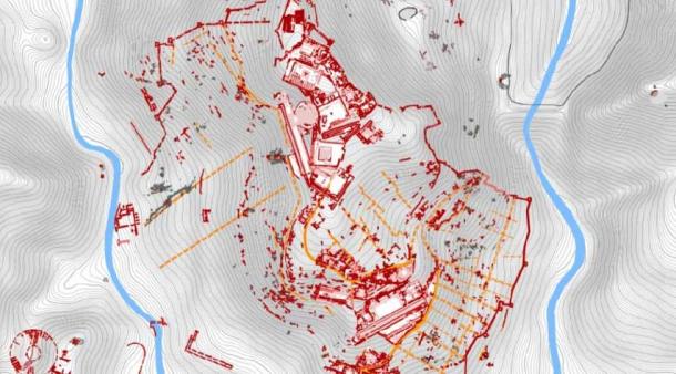
The new digitalized map reveals the extent of the known metropolis of Pergamon and will be continuously updated. ( German Archaeological Institute )
Pergamon: An Ancient City Within Modern-day Turkey
Bergama is the present-day site of the ancient ruins of the kingdom of Pergamon. Bergama is a vibrant city, not much different from its predecessor, Pergamon.
King Lysimachus’ kingship, a successor of Alexander the Great , lasted approximately 20 years before it was mired with intrigue related to domestic issues. He was eventually killed in the Battle of Corupedium in which he faced off with an old rival, Seleucus I Nicator.
After King Lysimachus’ demise, his lieutenant Philetaerus established the Attalid dynasty. His family ruled from 281 BC to 133 BC, spreading Hellenistic culture far and wide within their city and beyond.
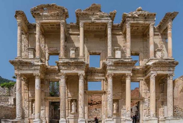
Under Attalid rule Pergamon became a cultural and artistic hub of Greece and rivalled the glorious city of Athens. The Attalids built an acropolis like the one in Athens within their city. The Library of Pergamon was also built under Attalid rule and was only second to Alexandria’s great library .
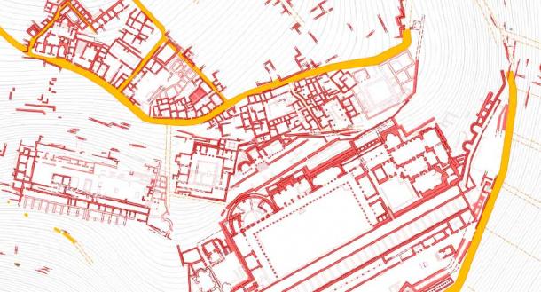
The digital Pergamon map details all the archaeological discoveries to date and can be continually updated. ( German Archaeological Institute )
The Attalid dynasty showed much favor toward the Romans, so it was no surprise that Attalus III bequeathed the city to the Romans upon his death. With no rightful heir, the city passed into Roman control but not without a challenge.
Aristonicus claimed to be Attalus III’s brother and fought the Roman army for control. He successfully led an uprising and usurped power from P. Licinius Crassus and his army. After Aristonicus’ brief stint, the Romans eventually regained control, and the city was divided into territories, with Rome taking the majority.
A Roman gate structure at Pergamon. ( praphab144 / Adobe Stock)
Pergamon Was A Roman City For A Long Time
Although the struggle between Aristonicus and Rome lasted for a few years, the Romans regained firm control over the city in 129 BC. Pergamon remained under Roman rule well into the Christian era.
Around 98 AD, under Emperor Trajan and his successors, Pergamon experienced a major building period in which massive temples and theaters were erected. Trajan had Trajaneum, or the Temple of Trajan, erected in his honor to serve as a place of worship for the god Zeus and himself. The Romans maintained control over Pergamon until 262 AD, when an earthquake damaged the city. Shortly after the earthquake, the Goths entered the city and sacked it.
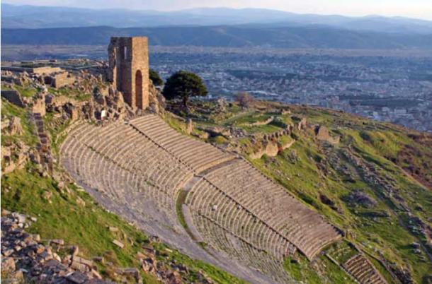
The huge amphitheater at Pergamon that rivalled the finest Greek versions of such theaters in that era. ( Ekaterina Ufimtseva / Adobe Stock)
The Fall of Pergamon
The city of Pergamon never recovered after the devastating earthquake and being sacked by the Goths. Emperor Constans II tried to infuse life back into this once great city, but its weak state left it open to capture by the Arabs in 663 AD. This ushered in the Byzantine period, which lasted until the Ottomans took over the region in the 1300s.
The ancient ruins of Pergamon still rest in the hands of the Turks and have become a significant site for excavation. Charles Cockrell produced some essential sketches of Pergamon in the 19th century. Carl Humann, a German engineer, discovered the Pergamon Altar while supervising road construction in Anatolia (modern-day Turkey). Upon discovering the ruins, he requested backing from Berlin Sculpture Museum to halt the ruins’ destruction and instead excavate the area. Many of his findings, with the agreement of the Ottoman government, became the property of Germany.
The German Archaeological Institute is also doing archaeological work in the area, which became a UNESCO World Heritage site in 2014. The new digital map allows researchers to see many ancient sites on the maps. The updated maps are much more accurate. They capture the research completed within the last 30 years and cover a much wider area than initially included on older maps.
Top image: The magnificent Pergamon acropolis that rivalled the one in Athens. Source: muratart / Adobe Stock
By ML Childs
 Posted in
  Tags:
Tags: 


