 RSS Feed


 April 8th, 2021
  Awake Goy
 A remarkable discovery, in what is being viewed as “Europe’s oldest known 3D map,” has been brought to light through a scientific collaboration effort. The “map” in question is a Bronze Age stone slab, 2m by 1.5m (5×6 feet), known as the Saint-Bélec slab, which was lost and then miraculously “rediscovered” in the cellar of a French castle in Brittany in 2014. First discovered in 1900, the Saint-Bélec slab is dated to the early Bronze Age, somewhere between 2150 BC and 1600 BC.
Researchers and historians from the French National Institute for Preventive Archaeological Research (Inrap), Bournemouth University, the CNRS, and the Universite de Bretagne Occidentale (UBO – University of Western Brittany) pooled their intellectual and financial resources, and published their findings in the prestigious French journal, Bulletin de la Société préhistorique française , with a summary published on Inrap.
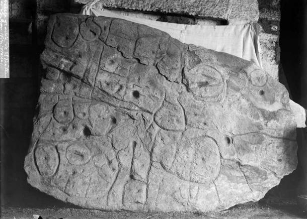
The first photograph of the Saint- Bélec slab, when it was found by Paul du Chatellier in Leuhan, Finistere, Brittany, France in 1900. ( Inrap)
The Saint-Belec Slab: Found, Acquired, Lost and Rediscovered
The Saint-Bélec slab was first discovered in an excavation by Paul du Chatellier in Leuhan, Brittany, France in 1900, inside an early Bronze Age barrow or grave mound.
It was moved to a private collection in the same year it was found. And then, in 1924, it was acquired by the French Musée des Antiquités Nationales, which is today known as the Museum of National Archaeology.
Till the 1990s, the Saint-Bélec slab lay forgotten in a niche in the castle moat at Mr. du Chatellier’s home, the Chateau de Kernuz, which is about 25 miles (40 km) southwest of Leuhan (where the slab was unearthed).
In 2014, the slab was rediscovered in the chateau. And in 2017, the cooperative research team began their examination of the slab. Their findings have now been published and they are amazing.
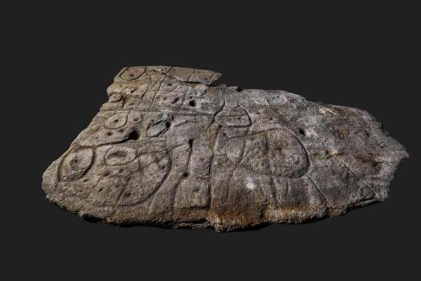
Overhead view of the Saint-Bélec slab. This ornate slab forms a homogeneous composition with covering engravings, identical in technique and style, forming an inseparable whole. Also note the repetition of patterns (cups, geometric shapes), linked together by a network of lines. These elements allow, according to C. Delano Smith, to recognize a cartographic document. ( Denis Glicksman / Inrap)
The findings proved to incredibly important. The Saint-Belec slab is conclusively interpreted as the oldest discovered cartographical representation of a known territory in Europe. Specifically, this was the territory and valley around the River Odet, in Western France. BU post-doctoral researcher Dr. Clement Nicolas, told the BBC that this was “probably the oldest map of a territory that has been identified.”
Photogrammetric coverage, geo-locating and high-resolution 3D surveys confirmed to 80% accuracy an 18-mile stretch along the Odet and its nearby valley, which is the area covered by the ancient stone map.
Dr. Nicolas stated, “There are several such maps carved in stone all over the world. Generally, they are just interpretations. But… this is the first time a map has depicted an area on a specific scale… probably a way to affirm the ownership of the territory by a small prince or king at the time.”

Lifting and positioning of the Bronze Age stone map that was luckily rediscovered in 2014 in the chateaux cellar. (Clément Nicolas, Yvan Pailler / Inrap)
Understanding an Ancient Stone Map With the Latest Science
The team recorded the surface topography of the Bronze Age slab and carried out an analysis of the morphology, technology, and chronology of the engravings. What they found was a trapezoidal motif at the center of the slab, which had convex edges. This trapezoidal shape was deeply engraved and bore two axes: a horizontal axis from edge to edge, and a vertical axis that was slightly broken and more difficult to decipher initially. Furthermore, a series of complex patterns, linked by a network of pecked lines, are dotted all over the stone slab.
Three factors related to prehistoric cartography revealed that this was indeed an ancient map:
- The homogenous composition with engravings identical in technique and style
- The repetition of motifs
- The spatial relationships between the lines
To confirm their hypotheses, the Saint-Belec slab was compared with similar representations from European prehistory.
The map’s central motif or line has been interpreted as an enclosure, probably from where the territory emanated or where it was centered.
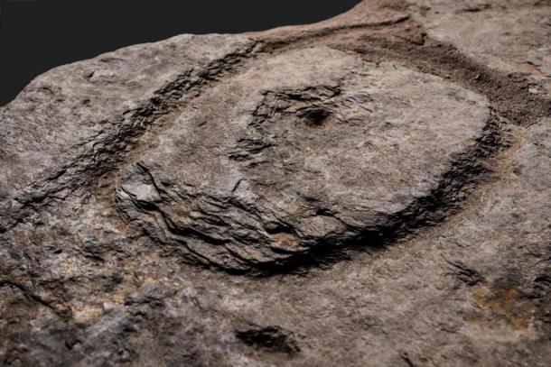
Detail view of a deeply pitted oval motif with a cup in its center. The picketing technique produces splintering of the shale, forming halos around the patterns. (Denis Glicksman / Inrap)
The researchers provided a set of fairly comprehensive conclusions from their research.
Firstly, it goes without saying that the ability of prehistoric societies to engage in formalized cartography and mind-mapping, was much more advanced than previously thought.
Secondly, the Saint-Belec slab is contemporaneous with the famous Nebra sky disk from Germany which is date to about 1600 BC. The Nebra sky disk Nebra is considered to be the oldest concrete depiction of the cosmos in Europe.
Finally, there probably existed a political entity led by a prince or a king, who wanted their territory to be literally cast in stone.
Top image: Overhead view of the Saint-Bélec slab. Source: Denis Glicksman / Inrap
By Rudra Bhushan
References
BBC. 2021. Bronze Age Slab Found in France is Oldest 3D Map in Europe. Available at: https://www.bbc.com/news/world-europe-56648055.
Inrap. 2021. The Oldest Map of Europe? Available at: https://www.inrap.fr/la-plus-ancienne-carte-d-europe-15574. (Translated from the French)
Liberatore, Stacy. 2021. Is the Oldest Map in Europe? Giant stone slab with markings etched 4,000 years ago depicts a region of France during the Bronze Age. Available at: https://www.dailymail.co.uk/sciencetech/article-9442343/Is-oldest-map-Europe-Stone-slab-markings-4-000-years-ago-shows-France.html.
Nicolas C., Pailler Y., Stéphan P., Pierson J., Aubry L., Le Gall B., Lacombe V., Rolet J. 2021. La carte et le territoire : la dalle gravée du Bronze ancien de Saint-Bélec (Leuhan, Finistère). Bulletin de la Société préhistorique française, 118, 1.
 Posted in
  Tags:
Tags: 


